

“Look at this!” Landis said excitedly, as he pointed to a map in his office at Prijon USA in Boulder, Colorado. “This river drops about 400 feet per mile in a couple of short sections, but most of it is about 150 to 200 feet per mile. It looks like an incredible canyon, and I don’t think that anyone has ever kayaked it.”
Landis Arnold had studied geography at Dartmouth College and had developed a passion for kayaking at the same time. He was also a Nordic jumper, and had become good friends with the Prijon family while he was training in Europe. The friendship became a business partnership, and he founded Prijon USA to import their kayaks to the United States. A good portion of his business involved testing kayaks. It was a tough job, but somebody had to do it.
Prijon had just come out with a new design called the T-Canyon, which had been designed for the steep creeks in Corsica, and Landis needed to test it on some rivers in the United States.
The river he had in mind was the North Saint Vrain, which flows out of Wild Basin in Rocky Mountain National Park. The only reasonable point of access for a kayaking run was a bridge on the Peak to Peak Highway, a popular scenic route that winds through the eastern slope of the Rockies between Nederland and Estes Park. From there, it was about twelve miles to another road below Button Rock Dam.
The team also included a very young Will Gadd and a seasoned ski patroller from Durango named Bo McWilliams. We met about dawn at the Prijon office, where we loaded all the gear into a large van and headed north and west toward the mountains.
“I think this is gonna be really cool, but we have to be careful because part of it is steeper than anything that I have ever done,” Landis jokingly warned us on the way out of town.
A small car was left at the planned takeout, and we continued onward in the Prijon van. The sky was clear, and the sun was just starting to show its brilliance as we reached the bridge where we’d planned to enter the river.
“The level looks perfect,” Landis said, looking at the nearly dry stream bed. So we quickly unloaded the boats, donned our gear, and headed downstream.
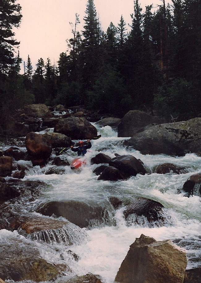
“The first section is really steep!” he informed us, as we headed down the heavily wooded creek. There was just enough water to float a boat, but that was plenty for an exploration run, and we descended quickly down the ever-steepening stream. Within minutes, we entered a very difficult rapid. But after a careful scout, we discovered too many logs to make it feasible, so we felt no guilt walking around it.
The group was able to run all of the log-less rapids, and after about a mile, the gradient eased. We entered a spectacular and very remote canyon that had moderate whitewater and no signs of civilization. A few tributaries gradually increased the stream flow, but we were able to eddy scout most of the rapids and bounce down the exciting stream. A small herd of bighorns watched in awe, and it was hard to believe that we were so close to a major city.
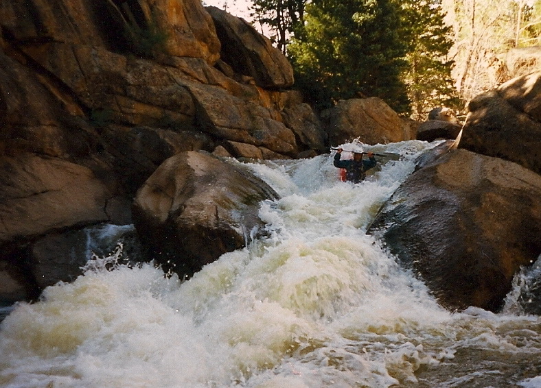
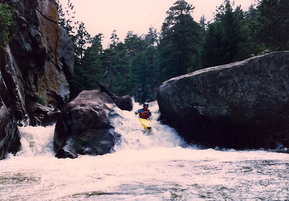
“The map showed another really steep section somewhere around here!” Landis exclaimed, as we stopped to scout a very steep, quarter-mile-long rapid. We couldn’t skip this one because of logs, and it looked somewhat reasonable, but it was much longer and harder than anything that we had ever paddled. Most of the group decided to portage the top third, but Will was eager to try the whole rapid, so we set up safety and watched anxiously as he launched his boat into the turmoil.
“There he goes!” Landis shouted. “He jumped that big rock, and he’s heading down that long, steep chute. Wow! Looking good.” Will’s achievement made Landis smile and shake his head in amazement. This was before boofing had become popular.
Within seconds, Will passed the eddy that the rest of us had decided to start in and motored on down the mostly unbroken rapid. It was very difficult to stop because the eddies were tiny, and a failed attempt could spin the kayak so it faced upstream, which is not very desirable. Will stayed focused and finally stopped at another bridge, where a lonely road headed off to civilization.
“Wow! That was really wild! I’m sure glad that I didn’t tip over,” Will yelled back to us, as he climbed out of his boat and grabbed his throw bag. The rest of us launched our boats from the lower eddy and found that two-thirds of the rapid was plenty exciting.
Just below the bridge was another, very steep, technical drop. “I’m gonna walk this one,” Will said. “It doesn’t look any harder than what we just did, but my adrenal gland needs a break.”
Bo thought he saw a line on the left and eagerly headed downstream. It was a very narrow and steep drop, and his Dancer was suddenly pinned vertically next to a large boulder. The three of us managed to pull him out and rescue his gear, but we had wasted valuable time, and the sun was quickly sinking toward the horizon.
The road looked tempting, but we didn’t really know where it went, and we were quite sure that we had passed the steepest section of the river, so we continued our descent. The gradient eased a bit as the river entered another steep-walled canyon with some beautiful Class IV rapids and at least one more Class V. The daylight was rapidly waning — as was the energy of the group — but we paddled onward in the near darkness.
“Look out! It looks like another big drop,” Will warned us, as he caught a small eddy. A quick scout revealed a short, technical rapid with flat water below it.
“I think we found the lake!” he yelled jubilantly. We quickly ran the drop and paddled across the reservoir in the near darkness. We were thrilled to be on flat water, but we still tried to imagine the great whitewater that had been submerged by Button Rock Dam.
It was very dark when we reached the lake, but a short portage and half a mile of easy paddling brought us safely to our car.
The next generation of extreme paddlers including Gordon Banks, David Eckhardt, Robby Dastun, Vince Taylor, Henry Filip and a few others cleaned out the wood and ran everything at some very high levels. This has become one of the front range extreme classics.
